The dinner is to be self-organized. You can either have your dinner at nearby restaurants or cook by your own using the kitchen provided by the guesthouse.
Highlights
Department of Surveying and Department of Theoretical Geodesy and Geoinformatics, Slovak
University of Technology in Bratislava
The Slovak University of
Technology in Bratislava (STU for short), the largest and most significant
university of technology in the Slovak Republic, is a modern European educational and
research institution. It offers university education mainly in technical, technological,
technical-economic, technical-information and technical-artistic fields of study. Its
activities reach back to the rich old tradition of the Mining Academy in Bratislava, established by the Empress Maria Theresa in 1762.
The Department of
Surveying at STU offers couroses including Land Surveying, Engineering
Surveying, Photogrammetry and Remote Senosing, Theories of Measurement and Data
Proocessing, Underground and Mine Surveying, Measuring Systems in Engineering Surveying,
Applied Analytical Photogrammetry, and Industrial Surveying. Research is oriented
towards the measureoment and prediction of deformations, the optimisation of the design
and measurement of local surveying control networks and the design and testing of
automatic measureoment systems, applications of analytical phootogrammetry terrestrial
laser scanning in architectural monument conoservation, environmental protection, water
maonagement and energy exploration.
The Department of
Theoretical Geodesy and Geoinformatics
at STU covers education in mathematical geodesy, physical geodesy, geodetic
astronomy, satellite geodeosy, processing and analysis of measurements, and
geoinformatics.
Their research activities conocentrate on geodetic monitoring and analysis of global,
regional and local geodynamic phenoomena, precise positioning by combinations of various
geodetic techniques, precise geoid deotermination, metrology and data processing, as
well as geoinformatics, spatial analysis, and predictive modelling.
Program
Start
End
Topic
09:30
-
Welcome address P. Kyrinovic, Vice Dean
-
-
History of the Uni, Departments and Study Programmes in Geodesy and Cartography A. Kopáčik, Department of Surveying
-
-
As-built verification of CE structures and BIM J. Erdélyi, Department of Surveying
-
-
Close-range photogrammetry applications – case studies M. Fraštia, Department of Surveying
-
-
Coffee Break
-
-
Geodesy on four continents - using of geospatial technologies in cultural heritage protection T. Lieskovský, Department of Global Geodesy and Geoinformatics
-
-
Water mass monitoring by gravity field changes J. Janák, Department of Global Geodesy and Geoinformatics
-
-
FG5-X absolute gravimeter demonstration J. Janák, J. Papčo, Department of Global Geodesy and Geoinformatics
-
12:30
Closing
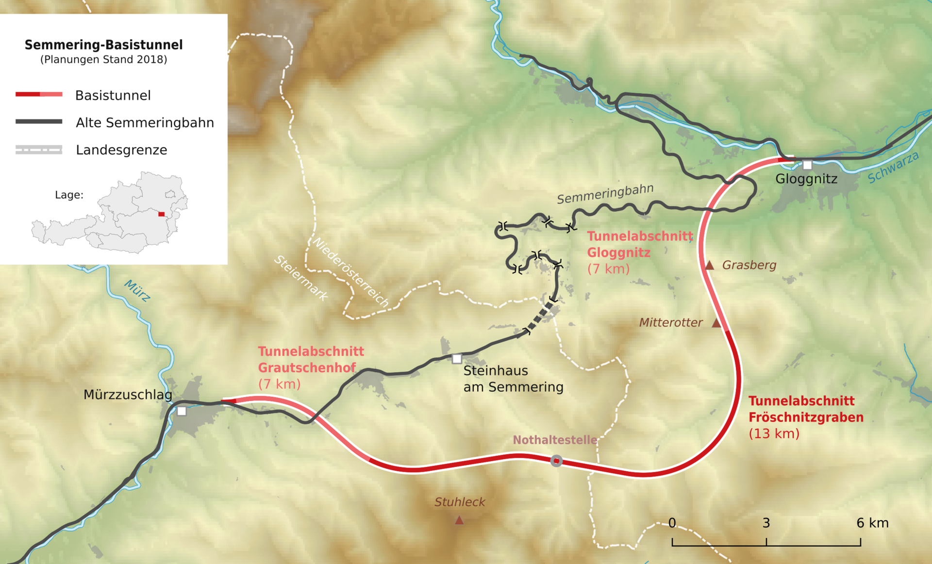
Infobox Gloggnitz of the Project Semmering Base Tunnel
The project Semmering
Base Tunnel (Semmering-Basistunnel)
is one of the most important infrastructure projects in the heart of Europe. As part of
the new Southern Line, the Semmering Base Tunnel creates a fast and safe connection
between Lower Austria and Styria.
From 2030, it will connect the town of Gloggnitz in Lower Austria with Mürzzuschlag in
Styria. This will relieve the historic Semmering
Railway (Semmeringbahn).
A total of 62 kilometres of tunnel are being excavated for the approximately 27 km-long
railway tunnel.
At the Infobox
Gloggnitz, the tunnel tube was recreated 1:1. The interactive stations - such as
a giant microscope or a sound box with animal sounds - are particularly appealing.
Program
Start
End
Topic
15:30
16:30
Guided tour with the Semmering Project Leader D. Haas
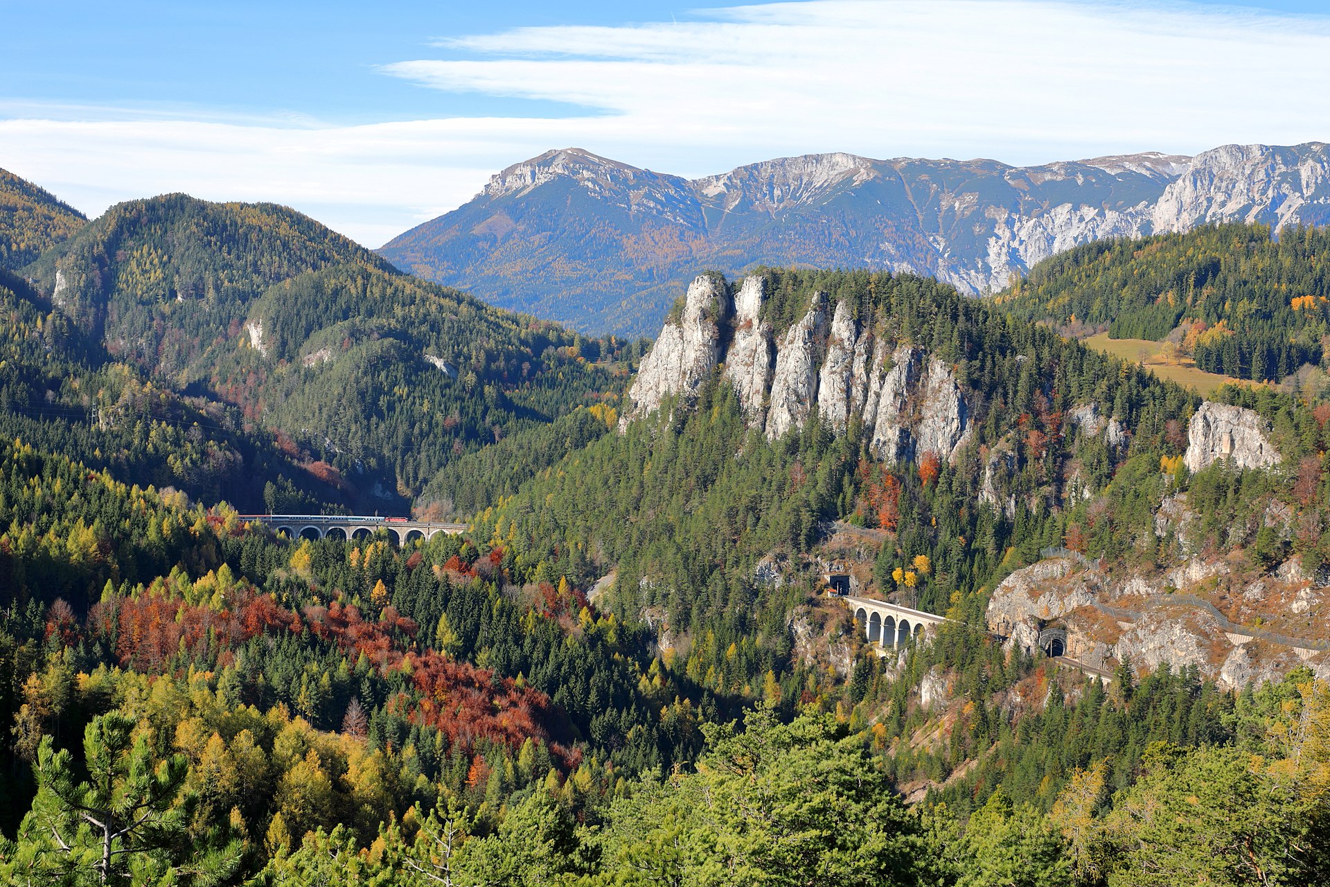
Semmering Railway
The Semmering
Railway (Semmeringbahn)
starts at Gloggnitz and leads over the Semmering to Mürzzuschlag, was the first mountain
railway in Europe built with a standard gauge track. It is commonly referred to as the
world's first true mountain railway, given the very difficult terrain and the
considerable altitude difference that was mastered during its construction. It is still
fully functional as a part of the Southern Railway which is operated by the Austrian Federal Railways (ÖBB).
The Semmering railway was constructed between 1848 and 1854 by some 20,000 workers. The
construction features 14 tunnels (among them the 1,431 m summit tunnel), 16 viaducts
(several two-storey) and over 100 stone arch bridges and 11 small iron bridges.
In 1998 the Semmering railway was added to the list of the UNESCO World Heritage sites.
The Kalte-Rinne-Viadukt is one of the two-storey viaducts. It is 182 meters long and 46
meters high.
The Doppelreiter observation tower (Doppelreiterwarte) is located at a height of 919
meters on the Wolfsbergkogel on the railway hiking trail that leads along the
Semmeringbahn. Just a few minutes' walk from the "20 Schilling" viewing area, you can
once again enjoy a breathtaking view of the UNESCO World Heritage Semmering Railway and
the surrounding area. The train stop Wolfsbergkogel is right below the observation
tower.